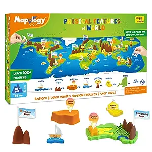
- 100+ FEATURES TO LEARN: Solve the puzzle with river, desert & lake shaped pieces, add the 3D mountains, volcanoes & plateaus to complete the map and get a play way experience of learning about the Physical Features of World
- FUN FACTS: Where is the largest single rock structure located? Did you know Angel Falls is the highest waterfall in the world? Get these answers & more in the Information and Construction Guide
- DUAL-SIDED MAT: This learning aid comes with a dual-sided mat where one side of the mat represents a political map and the other side represents a physical map. The topographical side shows additional features like waterfalls & lakes while solving from the political side helps understand the location of feature – such as the fact that Sahara Desert is located predominantly across 11 African Countries
- TRUSTED LEARNING AID: Designed keeping school curriculum and learning objectives like map skills in mind while consulting teachers and educators – this product is a great learning aid and also can be very useful for school projects
- CONTENTS: 6 continent Pieces, 1 Dual-Sided Mat, 23 3D Mountains & Plateaus, 32 River, Lake & Desert pieces, 60 Name Pegs, 60 Name Stickers, 1 Spray & Play Bottle, 1 Information & Construction Guide


Imagimake Mapology – Physical Features of World
| Colour | Multicolor |
| Brand | Imagimake |
| Map Type | World Map, Political Map, Topographic Map, Physical Map |
| Product Dimensions | 54L x 30W Centimeters |